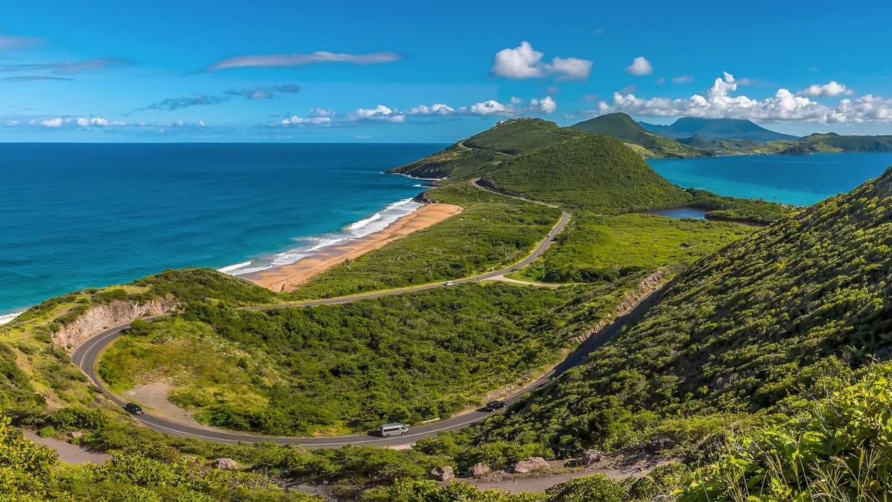
One road circles St Kitts. Roughly 30 miles around the main body of the island, about 90 minutes if you drove it without stopping, and the single best day you can spend here if you do it properly, which means stopping constantly. Fortresses, black sand, rum distilleries, batik studios, fishing villages, and roadside barbecue, all threaded on one loop you cannot get lost on.
Tour operators charge US$65 to US$95 per person for a few hours on this same road with three stops. The scenic railway circles it with no stops at all. A rental car gives your whole group the identical loop, every stop you want, for less than the price of one tour ticket. This is how to drive it like someone who lives here.
The Shape of the Loop
The main island road hugs the coast the entire way around, passing through every village. There is one meaningful decision: which direction to start.
West first (recommended for most): Heading west out of Basseterre takes you through the villages and past the heaviest concentration of attractions: Bloody Point, Old Road Town, Romney Manor, the Wingfield Estate and Old Road Rum distillery, Brimstone Hill Fortress, and Sandy Point, before rounding the northern tip at Dieppe Bay. You do the sightseeing while you are fresh and the day is cool, and lunch lands naturally in the north.
East first: The eastern side has its communities too, but you will find more farmland and open country than attractions. Its advantage is flexibility: the Kim Collins Highway connects the east side to Frigate Bay Road, so if you start east you can make a quick run to Frigate Bay or bail out early to the beaches whenever you have had enough. It is also the better return leg: after a full western morning and northern lunch, the emptier eastern road brings you home fast, with the Kim Collins Highway dropping you straight toward Frigate Bay for a sunset swim.
Getting Out of Basseterre
One myth to clear up first: travel forums love to claim St Kitts has no traffic lights. Basseterre has several sets, including at the top of Fort Street by Cayon Street, the bottom of Fort Street at Bay Road, Bakers Corner, Sandown Road at Bay Road, College Street at both Bay Road and Cayon Street, and out at Bird Rock by the supermarkets. What is true is that once you leave the capital, the island road itself has none: no lights, few stop signs, and roundabouts doing the work. Watch the one-way streets in the town core, get yourself onto the western coastal road, and the complicated part of your day is already over.
The Loop, Stop by Stop (West First)
Challengers and Bloody Point
Ten minutes out of town, the road squeezes into Challengers Village through a tight corner, and cars parked on the hillside often leave a single lane for traffic in both directions. Ease in, be ready to give way, and exchange the wave. Just before the village, a roadside marker at Bloody Point records the 1626 massacre of the Kalinago people, a two minute stop that sets the historical tone for the coast ahead.
Old Road Town, Romney Manor, and the Rum
The first British settlement in the Caribbean (1623), with Romney Manor and Caribelle Batik up the hill, the 400-year-old Saman tree, and the Old Road Rum Company pouring award-winning rum at the Wingfield Estate, the oldest surviving distillery site in the Caribbean, dating to 1681. Down in the village, Sprat Net’s clifftop fish lunch is a strong early option if you started late. Allow 45 minutes to an hour up at the estate.
Brimstone Hill Fortress
The UNESCO World Heritage fortress 800 feet above the coast, the single most impressive man-made thing on the island. The drive up is steep and narrow with hairpins, so take it in a low gear and use your horn on the blind bends. Budget an hour to 90 minutes at the top.
Sandy Point and the Northwest
The road continues through Sandy Point, the island’s second town, then swings around the flank of Mount Liamuiga through Newton Ground and St Paul’s. This stretch is pure village St Kitts: church spires, fruit stands, schoolchildren, and the mountain always on your right.
Dieppe Bay, Lunch on Black Sand
Dieppe Bay is the natural lunch stop: a black sand fishing village where the Caribbean meets the Atlantic behind a sheltering reef. Mugzy’s (Reef Bar) and Arthur’s serve fish caught that morning. If the timing is right, this is the meal you will still be talking about at home.
Black Rocks
A few minutes past Dieppe Bay, the Black Rocks lava formations meet the Atlantic surf, with a barbecue chicken hut in the car park for anyone who skipped lunch. The half-hour here, wind in your face, is the wildest scenery on the loop.
The Atlantic Side Home
From Black Rocks the road runs down the eastern coast through Saddlers, Tabernacle, Molineux, and Cayon, with farmland rolling toward the sea. Watch for animals through here: goats, sheep, monkeys, dogs, and occasionally cattle treat the northeast stretch of road as their own. Traffic can bunch at Buckleys depending on the time of day. Then the Kim Collins Highway, named for the sprinter who brought St Kitts a world 100m title, carries you onto Frigate Bay Road for the finish.
The Optional Peninsula Extension
If daylight and energy remain, continue past Frigate Bay over Timothy Hill for the famous two-oceans photo, and down to Cockleshell Beach for a swim and a sundowner. This adds 60 to 90 minutes plus beach time, and turns the island loop into the complete St Kitts day.
How Long It Really Takes
- Nonstop: about 90 minutes at a moderate pace, but driving it nonstop misses the point entirely
- Half-day version: 4 to 5 hours with three or four stops (Romney Manor, Brimstone Hill, Black Rocks, quick lunch)
- The full day: 6 to 7 hours with the distillery, the fortress, a proper Dieppe Bay lunch, Black Rocks, and the peninsula extension
- Cruise passengers: the half-day version fits a normal port call comfortably. See the one day itinerary for a timed plan with buffers built in
What the Road Is Actually Like
Honest notes, the kind travellers trade on forums, verified locally:
- Two lanes the whole way, generally good surface, with potholes that seem to appear by magic. Nothing that troubles a standard car at sensible speeds
- No shoulders and few places to pull over outside the villages and lookouts, so plan your photo stops rather than improvising them
- Villagers park along the road and sometimes walk in it out of necessity. Slow down through every village, especially the Challengers pinch
- Local drivers know every bend and will overtake you when they get the chance. Let them. You are on holiday
- A horn tap here is a greeting, not a complaint. You will be honked at all day and it is friendly
- The main loop needs no SUV. It is the side tracks down to certain beaches that punish speed, so crawl on anything unpaved
- Fuel up in the Basseterre or Frigate Bay area before starting. Stations thin out around the northern half of the loop
The full rules, roundabout etiquette, and the temporary permit (EC$62.50, valid across the Federation of St Kitts and Nevis) are covered in the driving rules and safety article.
Loop by Car vs Tour vs Railway
The island tours run US$65 to US$95 per person for 2.5 to 4 hours, typically stopping three times. The scenic railway circles the island in about 3 hours with no stops at all, purely through the window. Both are fine products. But a rental car costs less than one tour ticket, covers everyone in your group, stops wherever and whenever you decide, lets you stay 20 minutes longer at the fortress because you want to, and adds the peninsula beaches at the end. For a family of four, the loop by rental car is roughly a quarter of the cost of putting the same four people on a tour, with triple the stops. That arithmetic is the whole case for driving it yourself.
A note on prices: tour rates, fuel costs, and attraction fees change over time. Treat the numbers here as a planning guide and confirm current prices before you travel.
Frequently Asked Questions
How long does it take to drive around St Kitts?
About 90 minutes nonstop at a moderate pace. With stops, plan 4 to 5 hours for the highlights or 6 to 7 hours for the full day with lunch and the peninsula extension.
How many miles is the drive around St Kitts?
Roughly 30 miles around the main island on the coastal road, plus an optional extension down the southeast peninsula.
Which direction should I drive the island loop?
West first for most visitors: the attractions cluster on the western coast, so you sightsee while fresh and return along the quieter eastern side, where the Kim Collins Highway gives a fast run back to Frigate Bay.
Can cruise passengers drive the full island loop?
Yes. The half-day version with three or four stops fits comfortably inside a normal port call, with time to spare for a swim.
Do I need an SUV for the island loop?
No. The main road is paved the whole way and fine for a standard car. Only some unpaved side tracks to beaches reward extra clearance.
Are there traffic lights in St Kitts?
Yes, in and around Basseterre, including on Fort Street, Bay Road, College Street, and at Bird Rock. Outside the capital, the island road has no traffic lights and uses roundabouts instead.
Related Reading
- Car Rental St Kitts
- One Day Driving Itinerary
- Basseterre on Foot and by Car
- Old Road Town and Romney Manor
- Brimstone Hill Fortress
- Dieppe Bay Black Sand Beach
- Black Rocks
- Frigate Bay and The Strip
- Timothy Hill Lookout
- Cockleshell Beach
- Best Beaches in St Kitts
- Beach Bar Driving Tour
- Driving Rules and Safety
- Temporary Driving Permit