St Kitts has one of the simplest road networks in the Caribbean. The island is only about 23 miles long, and a single main road loops around most of the coastline connecting nearly every destination visitors want to reach.
If you are renting a car, understanding the basic road layout takes about two minutes and eliminates any navigation anxiety. This guide explains the main roads, the key routes visitors use, and how the road system connects to beaches, historical sites, and resort areas.
The Main Road Network
St Kitts has one primary road that circles the island along the coast. Think of it as a loop with a tail:
- The loop runs from Basseterre west through the villages, north past Brimstone Hill, around the northern tip, and south down the Atlantic coast back to Basseterre
- The tail is the Southeast Peninsula Road, branching south from Frigate Bay toward Timothy Hill and Cockleshell Beach
That is essentially the entire road system visitors need to know. There are smaller roads branching into residential areas and up toward the volcano, but the main coastal road and the peninsula road cover every major attraction.
Route 1: Basseterre to Frigate Bay
Distance: about 3 miles
Drive time: about 10 minutes
This is the most frequently driven route for visitors. It connects the capital (and the cruise port at Port Zante) to the main resort and beach area at Frigate Bay.
The road passes Robert Bradshaw International Airport along the way. From Frigate Bay, you can continue south onto the peninsula road toward Timothy Hill and the beaches.
Key landmarks on this route: Port Zante, central Basseterre, Robert Bradshaw Airport, Marriott Resort, Royal St Kitts Hotel, Sugar Bay Club, The Strip at Frigate Bay.
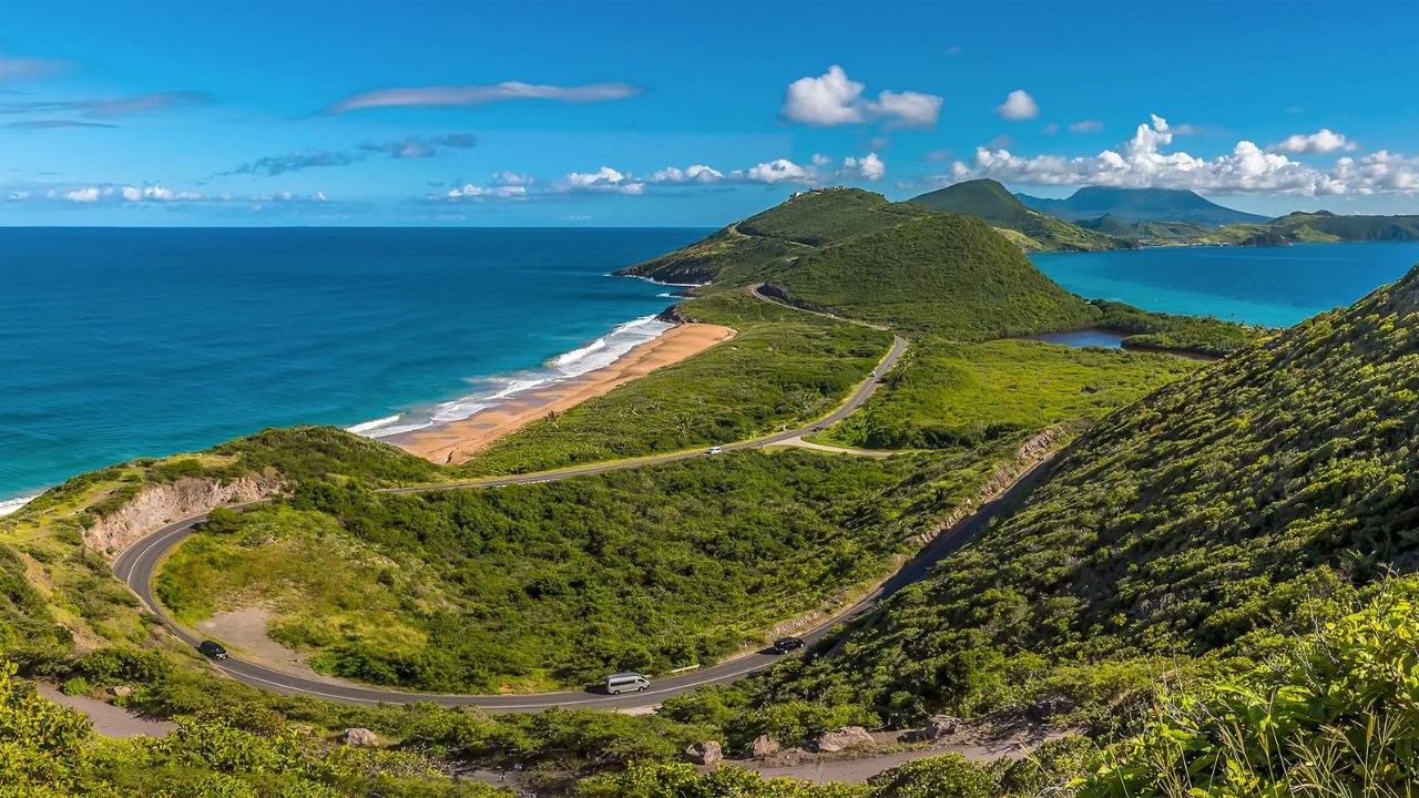
Route 2: Frigate Bay to Cockleshell Beach (The Peninsula Road)
Distance: about 6 miles from Frigate Bay
Drive time: about 20 minutes
This is the most scenic road on the island. After Frigate Bay, the road climbs to Timothy Hill Lookout, then descends along the narrow peninsula with ocean visible on both sides.
Turnoffs along the way lead to South Friars Bay, Sand Bank Bay, Reggae Beach, and Cockleshell Beach at the end of the road.
Road quality: well-paved throughout. Suitable for all vehicle types.
Route 3: Basseterre to Brimstone Hill (The Western Road)
Distance: about 12 miles
Drive time: about 35 to 45 minutes
This road heads west from Basseterre through Challengers, Old Road Town (the site of the first British settlement in the Caribbean), and past Romney Manor before reaching Brimstone Hill Fortress.
The road passes through several small villages and communities. Some sections are narrower than the peninsula road, especially through villages. Drive slowly and watch for pedestrians, speed bumps, and animals.
Key landmarks: Old Road Town, Wingfield Estate, Romney Manor (Caribelle Batik), Brimstone Hill Fortress (UNESCO World Heritage Site).
Route 4: Brimstone Hill to Black Rocks (The Northern Road)
Distance: about 10 miles
Drive time: about 25 to 30 minutes
Continuing from Brimstone Hill, the road loops around the northern tip of the island. The landscape becomes drier and more windswept as you move onto the Atlantic coast.
Dieppe Bay (black sand beach) and Black Rocks (volcanic formations) are the key stops along this stretch. From Black Rocks, the road continues south back toward Basseterre, completing the island loop.
Route 5: Black Rocks Back to Basseterre (The Eastern Road)
Distance: about 8 miles
Drive time: about 20 minutes
This stretch runs along the Atlantic coast back into Basseterre. The road is paved and straightforward. You pass through a few small communities and some open agricultural land before re-entering the capital.
Navigation Tips for Visitors
- You cannot really get lost. The main road follows the coast. If you stay on the coastal road, you will always loop back to Basseterre
- Road signs exist but are limited. Major intersections and tourist destinations are signposted, but smaller roads may not be. An offline map on your phone is helpful
- There are very few traffic lights. Most intersections use roundabouts. Give way to traffic already in the roundabout
- Google Maps works on the island for basic navigation. Download the St Kitts map for offline use before arriving
- Distances are short. Even the “longest” drive on the island (Basseterre to Brimstone Hill) takes under 45 minutes
Road Conditions
Main roads are paved and generally well maintained. Here is what to expect on each route:
- Peninsula Road: Excellent condition. Smooth, paved, wide enough for two-way traffic
- Western Road: Good condition overall. Some narrow sections through villages. Watch for speed bumps
- Northern Road: Paved but narrower in places. Some elevation changes and curves. Less frequently maintained than the south
- Beach access roads: Some are unpaved. Major’s Bay and a few remote beaches require a vehicle with higher clearance
For detailed driving conditions and rules, read: Driving in St Kitts, Rules, Safety, and Tips
How the Roads Connect to What You Want to See
Beaches: All main beaches are accessed from the peninsula road (Route 2) or from short turnoffs along the western road. See our beach driving guide
Historical sites: Brimstone Hill, Romney Manor, and Old Road Town are all along the western road (Route 3)
Hotels and resorts: Most are along the Basseterre to Frigate Bay corridor (Route 1). Park Hyatt is at the southern end of the peninsula road (Route 2)
The airport: Robert Bradshaw International Airport sits on Route 1 between Basseterre and Frigate Bay. See our airport rental guide
The cruise port: Port Zante is in the centre of Basseterre, at the starting point of all routes. See our cruise port rental guide
Frequently Asked Questions
Is it easy to navigate St Kitts by car?
Yes. The island has one main road that loops around the coast. Staying on the main road will always bring you back to Basseterre.
Do I need GPS to drive around St Kitts?
Not strictly necessary, but downloading Google Maps for offline use is helpful for finding specific beaches and turnoffs.
Are the roads paved?
All main roads are paved. Some beach access roads are unpaved but manageable in most vehicles.
How many traffic lights are there?
Very few. Most intersections use roundabouts. Give way to traffic already in the roundabout.
Can I drive to every attraction on the island?
Yes. Every major attraction in St Kitts is accessible by car via the main coastal road and the peninsula road.
Book Your Car Rental
Ready to explore the roads of St Kitts? Book your car rental today.